Geopal
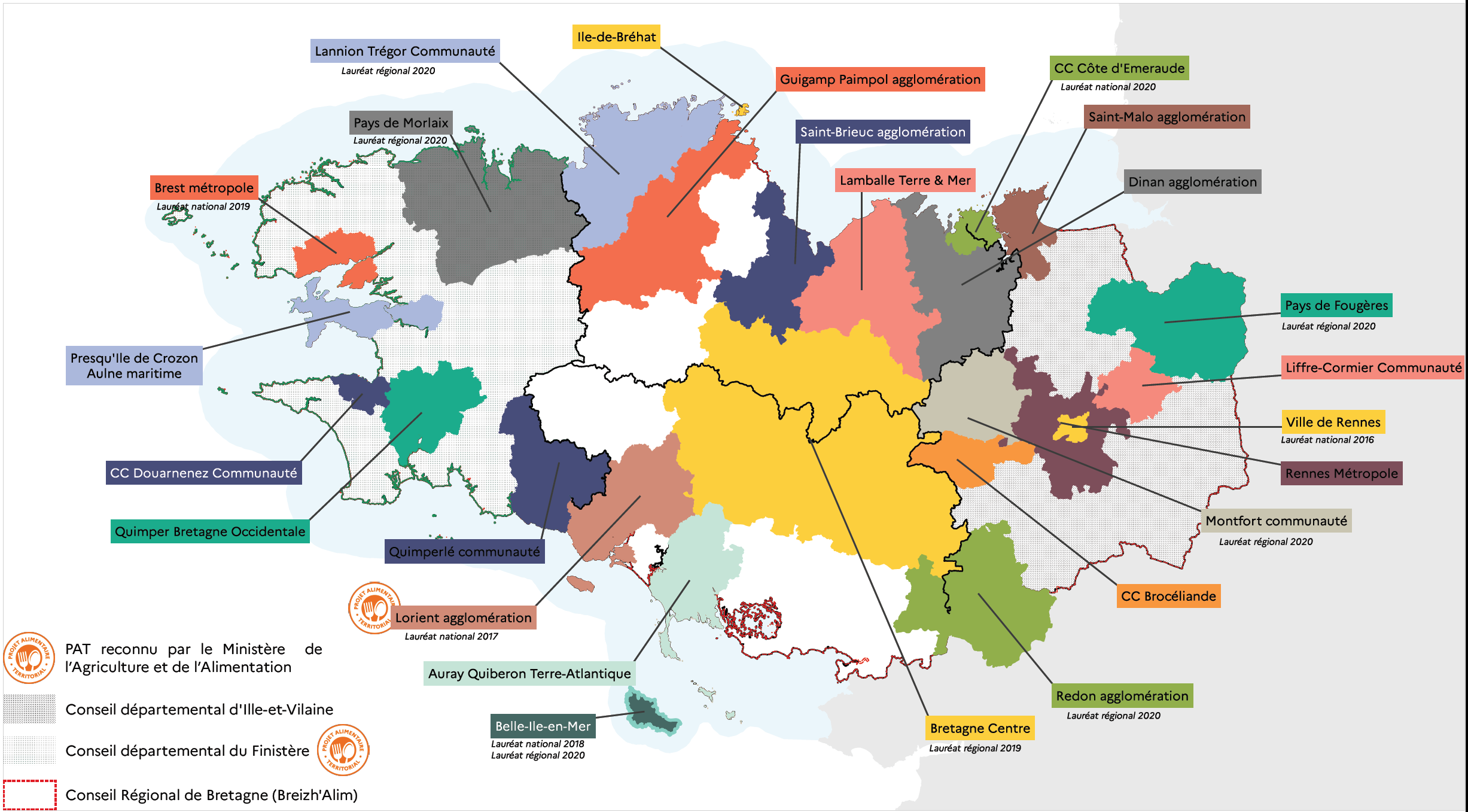
Les projets, systèmes et démarches alimentaires en Bretagne
Simple
- Date (Creation)
- 2021-02-12
- Identifier
- https://geobretagne.fr/geonetwork/srv/fre/xml_iso19139?uuid=85af0fa3-b961-4db5-a33e-a4cebc47f29e
- Status
- Completed
- Maintenance and update frequency
- As needed
- Place
-
- Bretagne
- Theme
-
- données ouvertes
- Démarche alimentaire
- Projet alimentaire territorial
- GEMET - Concepts, version 2.4
-
- projet
- développement du territoire
- GEMET - INSPIRE themes, version 1.0
-
- Santé et sécurité des personnes
- Use limitation
- Usage libre sous réserve des mentions obligatoires sur tout document de diffusion : "Source : DRAAF Bretagne"
- Use limitation
- Licence ouverte v2.0 : https://www.etalab.gouv.fr/wp-content/uploads/2017/04/ETALAB-Licence-Ouverte-v2.0.pdf
- Access constraints
- Other restrictions
- Use constraints
- License
- Other constraints
- Pas de restriction d’accès public
- Spatial representation type
- Vector
- Denominator
- 1100000
- Metadata language
- fre
- Topic category
-
- Economy
))
- Reference system identifier
- RGF93 / Lambert-93 (EPSG:2154)
- Topology level
- Abstract
- Geometric object type
- Surface
- Distribution format
-
-
ESRI Shapefile
(
1.0
)
-
ESRI Shapefile
(
1.0
)
- OnLine resource
-
Les projets, systèmes et démarches alimentaires en Bretagne - téléchargement simple
(
WWW:DOWNLOAD-1.0-http--download
)
Les projets, systèmes et démarches alimentaires en Bretagne - téléchargement simple
- OnLine resource
-
projets_alimentaires_r53
(
OGC:WMS
)
Projets
- OnLine resource
-
projets_alimentaires_r53
(
OGC:WFS
)
Projets
- OnLine resource
-
projets_alimentaires_r53
(
OGC:WMS-1.3.0-http-get-capabilities
)
Projets
- Hierarchy level
- Dataset
Conformance result
- Date (Publication)
- 2010-10-23
- Explanation
- Non Evalué
- Pass
- No
- Statement
- Les contours des projets s'appuient généralement sur des limites administratives de communes, d'EPCI, de départements ou de région. Les éléments sont donc issus des couches BD CARTO (IGN) des différents niveaux administratifs mentionnés.
- File identifier
- 85af0fa3-b961-4db5-a33e-a4cebc47f29e XML
- Metadata language
- fre
- Character set
- UTF8
- Hierarchy level
- Dataset
- Date stamp
- 2021-04-14T14:22:34
- Metadata standard name
- ISO 19115
Overviews
Spatial extent
Provided by