Geopal
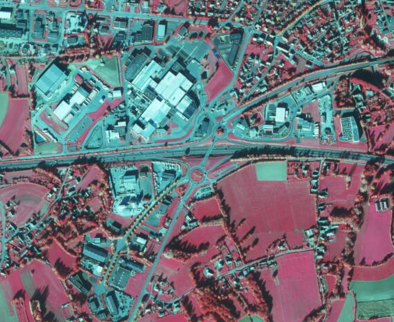
Orthophotographie infra-rouge des Côtes d'Armor 2021
Orthophotographie infra-rouge couleur réalisée sur le territoire des Côtes d'Armor en 2021 par l'IGN.
Caractéristiques techniques :
Résolution : 50 cm
Précision : 40 cm
La prise de vue a été réalisée en été 2021.
Simple
- Alternate title
- ir-22-2021
- Date (Publication)
- 2022-12-12T00:00:00
- Edition
- 2021
- Identifier
- FR-233500016-ir-22-2021
- Status
- Completed
- Hours of service
- hours of service
- Maintenance and update frequency
- As needed
- Maintenance note
- La mise à jour est prévue tous les 3 ans
- Place
-
- Côtes d'Armor
- Theme
-
- ortho
- données ouvertes
- infra rouge
- GEMET - INSPIRE themes, version 1.0
-
- Ortho-imagerie
- external
-
- image satellite
- external
-
- photographie aérienne
- GéoBretagne v 2.0
-
- référentiels : imagerie
- Use limitation
- Usage libre sous réserve des mentions obligatoires sur tout document de diffusion : "Source : IGN"
- Use limitation
- Licence ouverte : https://www.etalab.gouv.fr/licence-ouverte-open-licence
- Access constraints
- Other restrictions
- Use constraints
- License
- Other constraints
- Pas de restriction d’accès public
- Spatial representation type
- Grid
- Distance
- 0.2 m
- Metadata language
- fre
- Topic category
-
- Imagery base maps earth cover
- Description
- Côtes d'Armor
))
- Reference system identifier
- RGF93 / Lambert-93 / EPSG:2154
Distributor
- OnLine resource
-
ir-22-2021
(
OGC:WMS
)
Orthophotographie infra-rouge des Côtes d'Armor 2021 - Visualisation WMS
- OnLine resource
-
ir-22-2021
(
OGC:WCS
)
Orthophotographie infra-rouge des Côtes d'Armor 2021 - Téléchargement WCS
- OnLine resource
- Téléchargement IGN (format JP2000) ( WWW:DOWNLOAD-1.0-http--download )
- Hierarchy level
- Dataset
Conformance result
- Date (Publication)
- 2013-12-10
- Explanation
- Non Evalué
- Pass
- No
- Statement
- La prise de vue a été réalisée en été 2021.
- File identifier
- e9f594f7-a87f-4b4d-93ce-545c5d003c12 XML
- Metadata language
- fre
- Character set
- UTF8
- Hierarchy level
- Dataset
- Date stamp
- 2022-12-12T17:38:03
- Metadata standard name
- ISO 19115
- Metadata standard version
- 1.0
http://www.bretagne.fr
Overviews
Spatial extent
Provided by